
DISCLAIMER: Do NOT attempt this loop without route-finding experience, topo maps, a helmet, an ice ax, crampons, bear spray and ropes. A majority of the route is unmarked trails, mosquito infested, steep cliffs and bear country. Do not underestimate this route, it is extremely dangerous if you do.
Intro
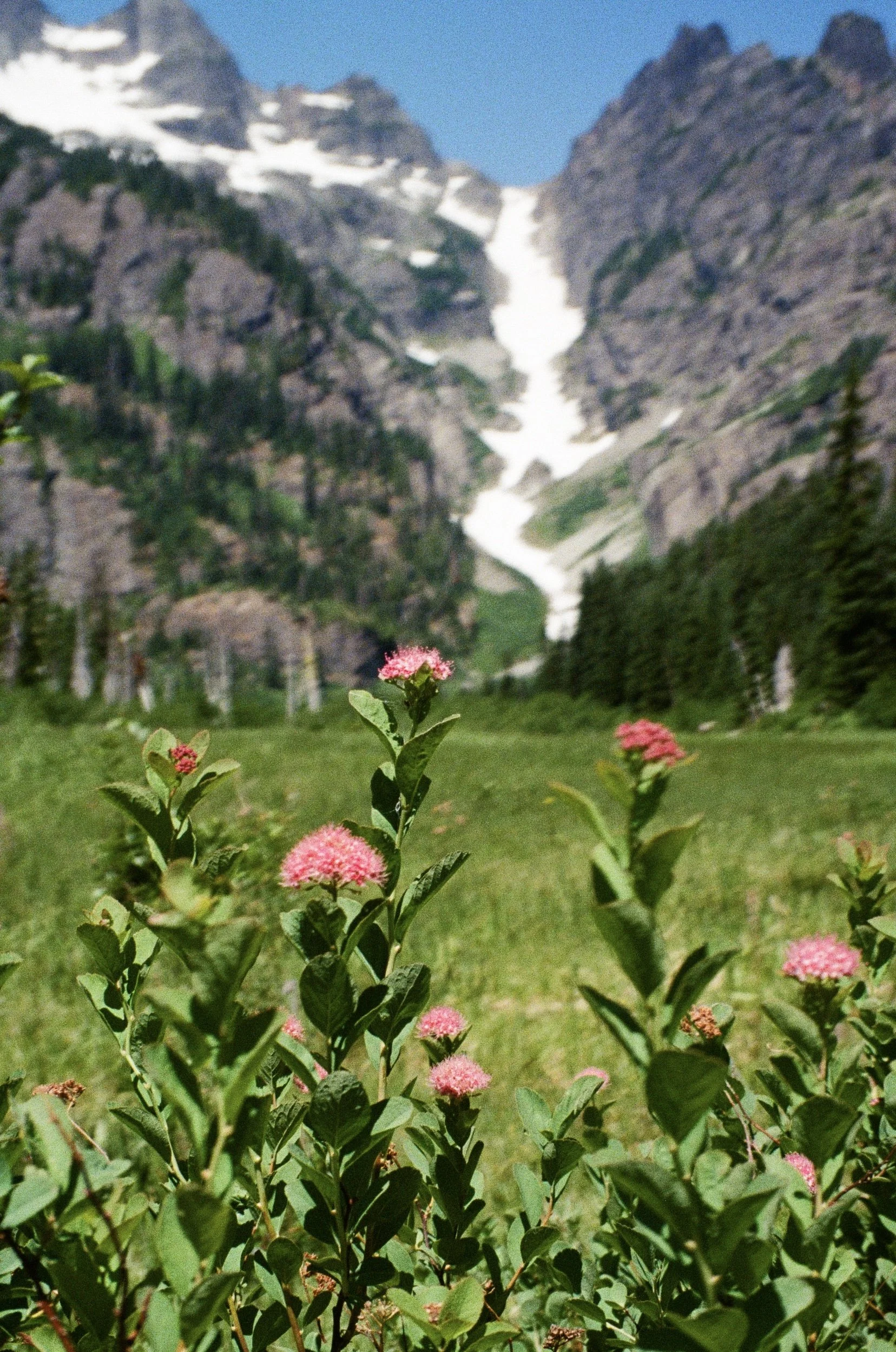
Back in 2016, I was talking to a coworker about a wilderness area in Washington when he brought up a meadow. There is no trail and he’d only seen photos of it, but the few he could find were gorgeous. Dramatic peaks towered in the distance and a huge waterfall plummeted into the open grassland, wild flowers and birds thriving in this small ecosystem. Tracing the source of the waterfall on Google Maps revealed a small, bright blue pool (tarn) at the base of jagged, black cliffs. Again, I could find very few photographs of the area and I was immediately intrigued. Lastly, multiple beautiful lakes dotted the other side of the ridge, and a primitive trail eventually met up with the PCT.
I considered the idea of a loop, starting and ending at a single trailhead. This would allow me to see and photograph the meadow, the rugged tarn, and upwards of 8 other alpine lakes in a single trip. At first, it didn’t seem doable. There were multiple river crossings, a snow finger (a stretch of unstable snow, in this case, that had accumulated in a dip between two steep cliffs), a glacier, extremely steep terrain and virtually no photos of some key areas. On top of that, the elevation gain and distance would make this a difficult trek. I searched through scattered climbers logs and studied topo maps, and slowly pieced together a potential route.
For a few years, I sat on the idea of the trip. I was fairly comfortable navigating off trail, but I’d never done a trip with so much route finding. Initially, I’d planned to go with a few friends that had done traverses through very similar country. However, when trying to decide where to hike one weekend, I brought it up to my wife Emily, who said she’d be down to go with me. I’d planned for 5 nights, 6 days, but Emily suggested we shorten the trip to 4 nights, 5 days, with the first night spent at the trailhead. This wouldn’t allow for as much time taking photos, but we could at least get a feel for the area and if I really wanted to come back I’d always have the option. We threw together some leftover food from our last backpacking trip, jumped in Rex the Van and headed to the wilderness.
Packing up our gear
Rex the Van
On our way to the trailhead, Emily started reading reviews of the first part of our hike.
“Bugs are BAD. Mosquitoes have no fear of DEET”
“Impossible to enjoy the lake, left early due to mosquitoes”
“Horse poop all over the trail and terrible bugs”
Not exactly 5 star reviews, however, we assumed once we got some elevation above the lake, we’d be able to escape the bugs. Pulling into the trailhead, we spent the night bundled up in Rex, while Emily read me a few chapters of “Murder On the Orient Express”. The pre-adventure butterflies had set in.
July 23rd 2021: The Approach
Our only goal was to get to the Pacific Crest Trail and potentially stay there for the night, depending on how we were feeling. This was our first backpacking trip of the season and we had not trained at all. Our bags were about 30lbs each, which wasn’t too bad, especially for how long we would be gone. Regardless, I was expecting we’d be taking our time. We left around 7:00 AM and, to our dismay, the reviews were spot on. No amount of DEET would deter the mosquitoes from our exposed skin. There weren’t a lot of them, but it didn’t take many to make you go a little crazy. 5 miles of this led us to the PCT and a much needed break from the bugs. We had done extremely well, it was only 10 o’clock and we had no intention of slowing down. From the PCT, we ventured off trail. What started as a primitive trail quickly turned into a faint animal trail, then nothing but thick foliage. Several beautiful waterfalls ushered us closer to our destination and after a fairly steep uphill and very thick brush, we burst through a bush and gawked at this gorgeous meadow.
Film photo by Emily

Film photo by Emily
Birds sang and bees buzzed in this little oasis. Wildflowers danced with the tall grass creating a pleasant white noise. You could see the wind take shape as it snaked through the wetlands, the two hundred foot waterfall roaring in the distance. It was 12:30 and the less desirable bugs had returned, however the breeze was keeping them occupied. Our next goal was reaching the opposite end of the meadow and the base of the snow finger. The ground was soggy and we did our best to tread lightly through the delicate ecosystem. About 1/3 of the way towards the snow, the terrain started to thicken. Bramble bushes grew intertwined and acted as walls protecting the rest of the valley, save for a few tunnels leading inward. These paths seemed heavily trafficked for such a remote area, and as I rearranged my footing, I saw a large pile of bear skat a few feet from me. Then a set of small paw prints to my right. I had known that we were in bear country, but it was now apparent we were in a bear’s home.
Seeing fresh bear sign definitely changed our mindset. It was most likely a black bear and they can be aggressive, especially with cubs. The wind was hitting us in the face, which meant a bear would not be able to smell us coming towards them. With the wind and the sound of the river, we would also be less likely to be heard. Ultimately, this meant crawling through thick bushes and bear tunnels probably wasn’t a good idea. The only thing worse than running into a bear is sneaking up on one. The last way up the valley that promised us amble visibility and a moderate degree of safety was through the freezing cold river.
We had, as you can imagine, not intended on hiking up a river when planning this adventure. As a result, I only had one pair of sandals. We made our way down to the water and I gave Emily my Tevas. I tied our boots to our bags, cinched our straps tight and in we went. The water was knee high in some places, waist high in others. Walking through the icy water helped numb my bare feet, making it easier to ignore the painful rocky river bed. Emily led us while we made sure to make plenty of noise. She yelled “AYO RIVER!” while I mostly stuck to “OW, ow, OUCH, eeeek”. At one point, the rocks became unbearable and I attempted to follow a path through the brush slightly set back from the river. As I turned the corner, I came to a dead end. A flat, circular clearing in the bramble bushes not 6ft in diameter. A bear had torn these bushes back and ripped up the ground to make a suitable day bed. Bits of fur hung on the protruding sticks surrounding me and I immediately headed back to the river. The odds of running into a bear were high and this reminder helped me push through the pain.
Bear poo
A shallow section of the river
The start of the snow finger
The thick vegetation turned to rock and we finally made it to the base of the snow finger. We dried our feet the best we could, put on our socks, our boots, and walked up to a snow cave for lunch. The bugs swarmed us, the only recourse was the cold wind blowing out of the cave, making it harder for the mosquitoes to stay in one place. “Don’t worry” I told Emily, “Once we gain a bit more altitude and get away from the valley, the bugs will disappear”. Waterfalls lined the left side of the chute, rushing off the tall rock walls and tumbling into massive holes they had carved through the snow. The water flowed through these holes into tunnels under the snow and ice, thinning out certain areas beneath our feet, but leaving little visible indication. This presented a very real danger when traversing the snow finger. Stepping in the wrong area could lead to a collapse and a very cold and deadly slip & slide. We decided to stick to the alpine heather and other small vegetation along the side of the chute as long as we could manage until a suitable entry point presented itself. Then, we would take our time and pay attention to where the rivers were flowing beneath us.
The Snow Finger
Crampons would have been ideal here. Instead, we had to to use force and our own boots to make it up. Trying to walk straight up was impossible, it was far too steep and slippery. To make any kind of progress, I jammed my boot over and over into the steep snowy cliff until a somewhat secure step was formed. From there, I hoisted myself up and started the process with my other boot, creating a makeshift staircase. I did this in one direction, then doubled back and started heading slightly upwards in the opposite direction. A continuous zig zag pattern. Stomp, step, swat bugs, rest, repeat.
It was exhausting. Kicking into the snow over and over was draining, especially with a full multi-day backpacking bag. Not to mention the snow was scattered with debris, rocks and trees that had fallen from the towering cliffs on either side of us, making us wonder when the next object would lob itself off the cliffs towards us. To top it off, the mosquitoes were not getting better like I had hoped. In fact, they were getting far worse.
Emily’s snow finger
Our route up from the valley
The terrain continued to transition between steep snow and wet rock. At one point, we noticed the snow finger seemed to just drop off a good 100 feet in front of us, so we made sure to leave the snow before getting anywhere near the edge. We followed a rock ledge to the left which eventually led us along the side of the gap in the snow, and we could then see why it disappeared. The water must have dropped 50 feet from where we stood down into a gaping icy well. We tried to see the bottom, but it was a black, roaring abyss. Emily adjusted her pack and rearranged her footing. I saw something shoot off the rocks out of the corner of my eye. The bright orange can of bear spray she was carrying had decided to eject itself from its “secure” side pouch and into the darkness it flew, devoured by the river.
So many waterfalls
Very steep terrain
We made our way up the gully until I was fairly certain I’d found our exit point. The terrain got steeper with each step and I began to make double trips helping Emily with her bag. Emily is extremely capable, but I wanted her to conserve her energy and be able to focus on her footing as much as possible. We crossed a small but fast flowing river and the terrain was getting very slippery. We hiked up more steep heather and I noticed a large hole in the side of the mountain. A path inside appeared to have been trafficked enough to form a small trail. I am fairly certain this was a seasonal bear den with the size of the opening. We were both exhausted, so I decided to not stop for a photo. I also made a point to not mention it to Emily, due to our situation.
Our situation being this: we were in panic mode. Not because of the slippery, steep terrain. Not because of the bears. Not because of our heavy bags & exhaustion and not because we were losing light; granted all reasons to warrant concern. We were, quite literally, being suffocated by mosquitoes. My assumption that the mosquitoes would subside was regrettably false. We both had our own unrelenting cloud of bloodsucking insects, flying in chaotic formation around our faces, darting at our eyes, buzzing passed our ears. They were bold and unafraid of our DEET based deterrent. Despite being completely winded, we were hesitant to take a deep breath for fear of swallowing them or getting them in our nose. There was no relief from them unless we were moving, and we desperately needed a break. The grade was steep enough that we needed to use our hands to climb, so we couldn’t always swat the devils away. When we did attempt to rest, we took shifts fanning eachother with my brimmed hat, however our efforts were hardly effective. We felt this rising panic for a majority of our hike from the meadow, but it was now culminating into something that could not be ignored.
Looking down into the chute we came from
We reached a plateau (literally and figuratively) at 6:00 PM. Emily and I were drained, and our only objective was finding a respite from the bugs. I saw a level rocky area in the distance and declared our hike was over for the day. I ran ahead and found the perfect spot for our tent, set it up faster than I thought possible, and had Emily carefully climb in while I glissaded (fancy word for a controlled butt-slide down snow) to her bag and the rest of our gear, which we had left a bit further down the cliff. I started to filter our water and was distressed to find my filter was not functioning correctly. It took me 10x as long to get half the normal amount of water into our bottles, and the mosquitoes took full advantage of my occupied hands and stationary body. I got what I could and ran for the tent, unzipped it halfway and squeezed in with Emily. I threw myself on my sleeping pad and let out a massive sigh of relief. Mosquitoes poked their tiny heads through the mesh of our tent, trying to get one last taste. But Emily and I were finally safe to relax. I’m definitely a bug lover, but I enjoyed squishing as many mosquitoes between our rain cover & the mesh of the tent as I could. As we laid down to sleep, I wondered why there were so many. “They must’ve followed us from the valley” I thought. “They’ll be gone in the morning.” The wind started to pick up and whipped the sides of our tent furiously. We had hiked such a long way and covered way more ground than we had hoped, but we couldn’t quite fall asleep.
Glissading with my trekking pole
10+ waterfalls behind our tent
The night came and went, but the mosquitoes stayed put. We packed up most of our gear inside the tent and scrambled to get the tent put away, taking sprint “breaks” in between to try and lose the bugs. I had just barely woken up and I was already feeling drained. Once we were packed and moving, it wasn’t long before I wanted to pull out the tent again to hide. We reached a rocky section, and after about an hour, our destination.
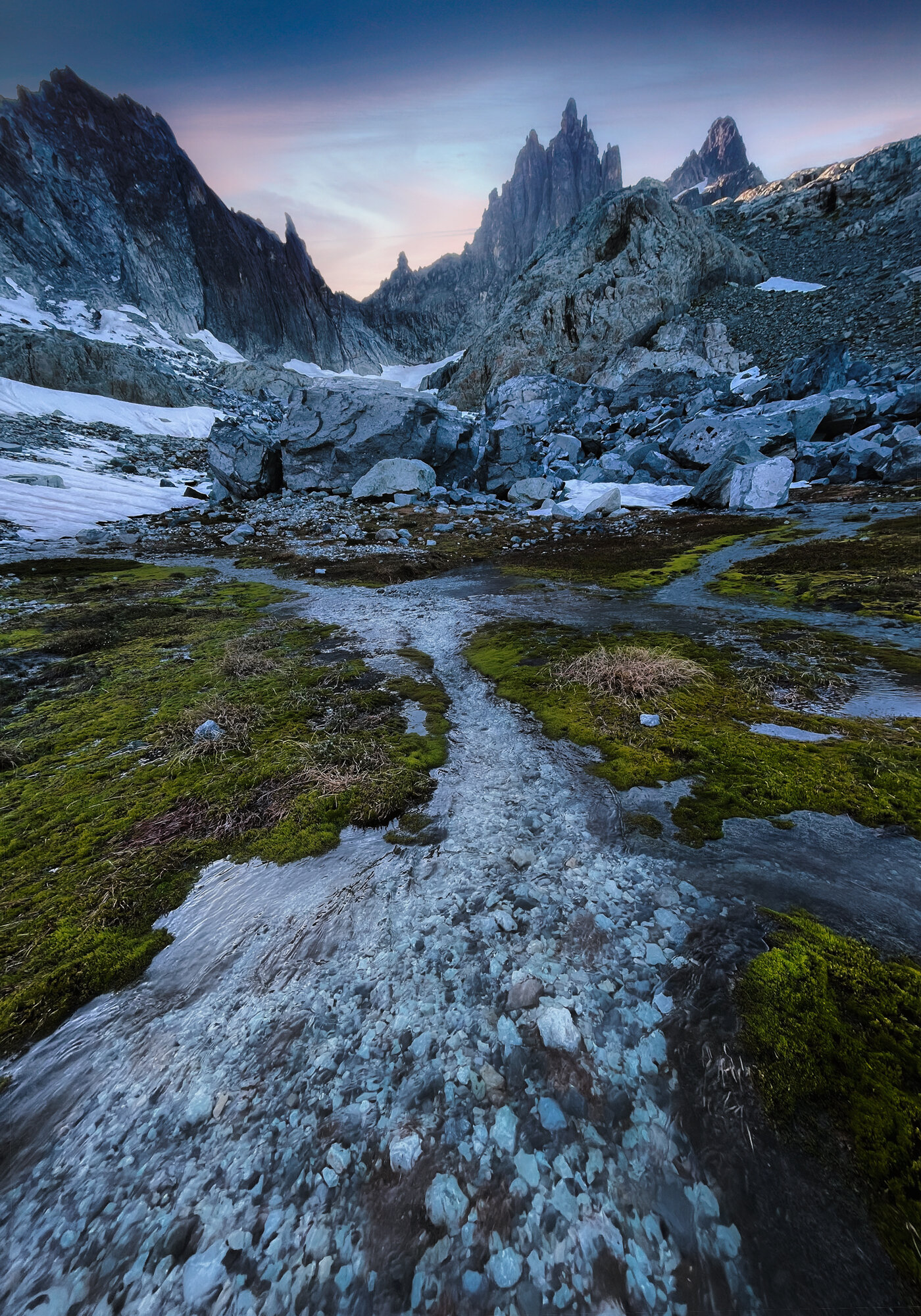
The Tarns
It goes without saying the skeeters had followed us all morning, so we quickly put our tent up and waited for the wind to save us. I desperately said a prayer and as if by devine intervention, the mountains took a breath and the wind blew. The mosquitoes were no more. I cautiously unzipped the tent and felt my muscles release their tension. We could let our guard down. We decided to dedicate the whole afternoon to relaxing and enjoying our beautiful alpine swimming pool. After a skinny dip in the lower tarn followed by sun bathing on some large boulders, we had lunch and Emily read me a few chapters from her book.
Our tent in the bottom left. The massive rock in the middle of the image had broken off and tumbled over a half-mile before coming to it’s resting place.
The mountain air was medicine to our tired lungs. The wind was light but kept the bugs at bay. The sun kept us warm and sparkled across the bright blue water like diamonds. Silence all around. Such a hostile and remote place, and yet, peace.
After hours of relaxation, I felt rested and recharged. It was time to find a way over the ridge. I told Emily I’d be back in 40 minutes and set off up the snowy outskirts of a glacier. Soon I was zigzagging up steep snow and traversing large boulders until finally I reached the base of the ridge. It looked impossibly steep from further back, but honestly didn’t look much better up close. I scanned three possible routes and headed towards the one that looked most promising. After fighting the slippery slope for quite some time, falling here and there, I eventually made it up the snow to the last, and most dangerous, section of steep loose rock. I took some photos to study later and decided to head back down. I stopped at this incredible blue pool that, in a few months time, would be swimmable. I didn’t get too close for fear of falling through the ice, but I would love to visit this tarn again when it’s a bit less dangerous.
Not sure if this has a name but “Castle Tarn” seems fitting
The trek was about a mile round trip and took me ~30 min. I told Emily the route was a bit more challenging than I had hoped and, with her safety in mind, decided to take her bag filled with non-essential gear up to the rock section and leave it there overnight. I had the energy now and preferred to let Emily focus on her footing rather than worry about extra weight holding her back. We rearranged our gear and up I went as the sun was starting to set. I made it almost to the top of the ridge before hitting an extremely steep section that I didn’t feel comfortable doing alone. I nestled Emilys pack into the rocks and headed back down. For whatever reason, my camera was deemed non-essential and was left in the pack. As I made my way back to our tent, I saw a beautiful composition. I was quite disappointed I didn’t have my camera and considered running back up to grab it. In the end, my phone did a fine job capturing the scene.
Our route and a general spot of where I left Emily’s bag (small yellow arrow)
The bag drop
We ate some ramen and got ourselves ready for bed. The alpine wind had picked up and whipped along both sides of our tent. I attempted to use rocks to stretch the shell of the tent in…creative…ways to try and prevent the loose nylon from flapping in the wind. I was somewhat successful, but overall gave in to the fact that we would have a noisy tent as long as the wind kept blowing. We laid our heads down and shot straight back up when we heard a crackle in the distance. Then a deep BOOM. What might have been mistaken for thunder elsewhere was instantly recognized as a falling boulder. We were far enough from the rock ridges and spires that we felt safe, however it was evident when we explored earlier that falling rocks had indeed found their home not too far from our tent. “Do you think my bag will be ok?” asked Emily. I pictured the bag being smashed by a careening boulder and scattering my camera equipment all over the mountain “I’m sure it’ll be fine…” We heard the rain of scree trailing down after the large boulder and then the silence of the mountains.
My wife plotting to kill me
The Accident & The Cave
We both slept alright despite the wind throwing the tent in all directions. We were up with the sun and made our way slowly up the snow and rock until we reached the steep section of snow. We saw something moving to our right, his white coat making him nearly invisible. A single mountain goat was laying in the snow, taking in the first rays of sunshine. Seeing wild animals is always a thrill, no matter how many you’ve seen, and we watched him for a few minutes with curiosity. I began to question whether the goat had come down the gully behind him, which lead me to believe maybe that was a better route. Just then, a rock broke loose from the cliff above the gully and went tumbling down the snow. The goat stood up and looked over his shoulder and his head followed the boulder as it rocketed past him. He took a few side steps out of the path of future rocks, keeping his eye on the mountains, and then plopped back onto the snow. The scene was honestly very funny, how blasé he seemed having almost been hit by the meteor. It made me feel much more secure about my chosen route.
Can you spot the mountain goat?
Cheesin x2
Cheesin
The steepest, sketchiest section of loose rocks
We zigzagged up the steepest snow yet, cleared the snow moats on the edge of the rock field and climbed up the rocks to discover Emily’s bag and it’s contents were safe and sound. I scrambled up the vertical skree with a rope and, after reaching a stable spot, threw the rope down to Emily. She secured the first bag and I hauled it up the wall. I pulled up the second bag and then helped Emily up as well. We were so close to the ridge, but we still had one last steep section to conquer. I climbed up a class 4 section and decided it wouldn’t be a great route for Emily, being as exposed as it was. I decided to have her tie her bag one last time so I could pull it up and free her hands to tackle this last section. Emily positioned herself and her bag on a large rock that I had walked across moments ago. The rock moved slightly. Emily started to shift her weight, but the rock gave way. It gained speed and hurled itself towards the glacier, with Emily in tow. “I’m falling!”, she yelled. Before she gained too much speed, with two fingers, she grabbed a rock above her head and with her other hand, grabbed the backpack with all our gear, and hung suspended amongst the scree and loose rocks falling on either side of her. I dropped my bag and rope and threw myself down the rocks to get to Emily. “I’m slipping!” She yelled. I slid down some rocks, scraping my hand but wasting no time. I made it to where she hung and pulled her off the scree slide and onto more solid ground. We sat for a moment taking in what just happened and I noticed a huge scrape on Emilys leg. “I don’t wanna look at it”, she said, and pulled her sock up and over the wound. It wasn’t too painful and she could walk ok. The situation wasn’t ideal, but the outcome could have been much worse. We shook off the adrenaline rush, did our best to bury our fears and pushed on to the ridge. The view of the other side was an ample reward for our efforts.
Click and drag the image below to explore an almost 360 degree view from the ridge. See if you can spot the tarn we camped at the night before.
I’m fairly certain this particular ridge sees few human visitors, but scattered along the ground were bits of white fur and flattened beds in the gravel. Mountain goats had this view all to themselves 90% of the time, and we felt humbled to be able to experience what, to them, is just another lazy afternoon. However, we were not mountain goats. We’d been through hell getting this far, and we hoped that going down would be easier. The terrain looked very different from the topographical map I had been studying. And by different, I mean steeper. Much steeper. I had Emily sit amongst some steady rocks while I scouted a route down. 20 minutes later I returned, “Well, we definitely can’t get down that way, there’s a huge cliff” I said reluctantly. Emily struggled with my constant coming and going. She couldn’t always see me when I scouted ahead, which made her understandably anxious. We continued up the ridge and I dropped my bag and explored another route. It was extremely exposed and I didn’t feel comfortable doing it without ropes especially with our bags. “That’s not the way either”. We were starting to get discouraged. How we longed for a trail with a definite destination. The unknowns were numerous and going back the way we came felt unimaginable, but sometimes, route-finding is all about trial and error. As we climbed further up the ridge, I saw a small chute heading down the way we needed to go. It was steep and it was slippery, but it was doable if we took our time. Emily and I made our way down this chute over the next hour until we hit a rock ledge. We inched along the rock with our faces to the cliff and our backs to the open air, steep cliffs below. I felt my pack catch against the wall and I immediately froze. I realized it was our tent poles which I had fastened to the outside of my bag. They shifted slightly but stayed put, save for one bunch that was destined to make the bottom of the cliff it’s new home. It slipped out. I reached and grabbed the pole before it fell to it’s doom. It then, comically, started assembling itself in mid-air. I pulled it back in, disconnected the segments and held it tight as we continued on the skinny catwalk. The ledge started to widen and we found ourselves looking at an incredible sight: a cliff-side cave.
Multi-photo panorama from the mouth of the cave
Emily’s film shot from the cave
iPhone pano
Five mountain lakes shone like jewels in the afternoon sun and many layered peaks dotted the horizon; Truly a window into another world. After a snack and a few photos, I told Emily to sit tight and continued my search for a way down. This was a big moment. If we didn’t find a way to the lake from here, I was out of ideas, and it would be a lot more work going back the way we came. After climbing up some prickly foliage, I took a few big steps up to a ledge. And there it was. I let out a celebratory “WOOO!” that echoed endlessly into the expanse before me. I could see a way down to a shoulder about halfway to the lake. From there I knew we could find a way down. I returned to an overjoyed Emily and we carefully descended the rocks. After some instruction, Emily glissaded for the first time and we made it down the last snow patch. Finally we felt the level grass under our feet like a long lost friend. From there, some more route finding was required to navigate the dense trees intermixed with steep cliffs. After an hour of playing limbo, climbing and crawling amongst the maze of dense pines, we poked our heads through the conifers and saw a clear path to the lake. We also spotted something alive moving towards us.
Our route down off the ridge
”A PERSON!” screamed Emily in disbelief. She waved frantically and the speck in the distance waved back. It was then I realized we hadn’t seen another human since we left the PCT two days prior. We made it to the lakeside and threw our bags to the ground.
The hardest part was finally over. It had been the most physically and mentally demanding trip I had ever been on, and getting us to this point safely was something I was proud of. Emily’s slip had also been very stressful. I hadn’t fully processed it until this moment because I wanted to keep a level head and stay positive. Teary-eyed, I gave her a hug and told her I was thankful she was ok. She thanked me for getting us this far. “I’m really glad I married you” she said, which was not something I expected to hear. She must have forgotten who had planned this trip in the first place. We found a place for our tent and cleaned her scrape with our first-aid kit. We spent the rest of the day taking photos and exploring our home for the night. We also met the person we had seen earlier and we had dinner together. He had hiked up alone and I think we both enjoyed the company! He takes some great photos, check him out on instagram! @its_djayy
Our home for the night

Evening light in the mountains
Going Down
We retired to our tent for the night, tucked away from the wind in a oversized, dried up puddle we found. It doesn’t sound glamorous, but it was a level dirt patch hidden from the wind. 5 star accommodations. We recounted our time on the ridge. “We were birds” Emily said. Filled with a sense of accomplishment and a warm meal, we fell fast asleep for the entirety of the night, a first on our wild trip. Morning came quickly and we packed up, took a few photos and headed down the trail. 17 miles to go. We wanted to make it home in a day, but it was going to be a LONG one.
How many lakes and waterfalls can you spot?
Each image in this sequence is zoomed in a bit more, showing our cave and the impossible looking cliff we descended
Sometimes you can spot little frogs in these small pools
A big ol’ rock
The top of the last steep section looking down the way we came
The climb down was rocky and had some very interesting monolithic features along the river. After a decent amount of elevation loss and cairn hunting, we came to a beautiful lake. We stopped for a breather and noticed a tent next to the lake. “How’s it going guys?”, said the tent. It would seem odd that a group of hikers were just sitting in their tent in the middle of the day, if it weren’t for the mosquitoes of course. They were back and we were not enthused. We said farewell to the tent and kept hiking. The trail disappeared, and the only way home was up, the last strenuous and overgrown incline before a well trafficked trail. We climbed very slowly up a steep ravine, it was evident our muscles were about through with us. And then it hit me. The call of the wild. “Emily, this is kinda gross, but I need to number 2”. We were in the middle of a steep cliff and my issue was urgent. I did my business and met Emily a bit further up. “What a place for a shit” she laughed. A roar bellowed through the valley. Within a second, it grew so loud, both Emily and I ducked and an F16 fighter jet rocketed over our heads. I had heard stories from other hikers who had seen these fighter jets doing training exercises through these mountains. The pilot had flown upside down over us and it was almost possible to see him smirking in his cockpit he was so close. All I can say is I’m glad I had pooped a few minutes ago, because if I hadn’t, it would’ve been a long hike home. We reached the PCT, reapplied sunscreen, bug spray and had a snack. The rest of the hike home was fairly uneventful, save for a few details:
Emily’s burps. Emily had developed some loud burps on this section of the trail stemming from the fizzy tablets I put in her water. I had decorated her backpack with wildflowers and there was a large flower in her hair. The sun had left a bit of blush on her cheeks and she looked more beautiful than I could have imagined. We met a fellow hiker on the trail who was on his way south from Canada. He stopped to chat with Emily and she congratulated him on his journey so far. Before long, he went on his way. “Have a nice trip!” said Emily sweetly, and then let out the loudest, longest burp I’d ever heard. The guy seemed startled as he looked back over his shoulder. I laughed until I cried. But when I wiped my tears, I got a bug spray/sunscreen cocktail in my eyes and they immediately started burning. Then I was crying for a different reason. We were a mess.
The far right is where we came from, the far left is where we went
After making it to level ground, we came to what I thought would be a bridge crossing. To my surprise, there were three rivers and no bridges. Our feet were pretty banged up and to save Emily the hassle of taking her boots off, I slipped on my sandals and carried her to the other side. I went back for the bags and returned to Emily, happy the water level was a manageable depth. The cool glacial runoff felt amazing on my legs.
The last 5 miles truly felt like an eternity. It’s as if the mosquitoes knew we were leaving. The hoards came from the mountains, the snowy ravines, the lakes and every desolate place we had been over the past 4 days. They came from miles away to send us off with one last bite, and receive one last smack in the face by my irritated hand. We ran. The last 3 miles became a marathon to escape the torture we had imposed on ourselves. Our bags were pounds lighter but felt so heavy. Our muscles burned. Our blisters seared. Laying eyes on the back of that trailhead sign was a spiritual experience. We quite literally heaved our bags into the van, slammed the door shut, squeezed into the front seats and sealed the wilderness behind us. No more mosquitoes, no more backpacks, no more hiking. We had done it.
In 11 hours, we had hiked 17 miles and descended 3000 feet. We immediately drove straight to the closest Mexican restaurant and ate a huge meal. We had planned on driving the 4 hours home, but we were so exhausted (and chafed) that we decided to get a room for the night.

Our “we’re alive” text we sent to family members

Emily’s leg
Our final trip length came out to 36 miles with about 6000 ft. of elevation gain, and our sore arms and legs lasted for days. I feel very fortunate to have been able to do this hike with my wife. I learned a lot about myself and my relationship with her. We kept calm when confronted with new, scary challenges. We encouraged each other the entire way, even when we felt exhausted and hopeless. We got to experience a place very few people get to see. And we did it all together.

Emily’s blister walk. With her bandage and bug bites, she got some very strange looks in the super market.
Thanks for reading! If you enjoyed this story, please leave a comment below and let me know!